
Arches National Park
This map includes Arches National Park, The Highlands, Little Valley, Devils Garden, Lost Spring Canyon Wilderness area, Negro Bill Wilderness area, Scott M. Matheson Wetlands Preserve, Cache Valley, Delicate Arch, Broken Arch, Dark Angel, Double ...

Grand Teton National Park
This Trails Illustrated topographic map is the most comprehensive recreational map for Wyoming's Grand Teton National Park. Coverage includes Fort Meade Recreation Area, Black Hills Experimental Forest, Bridger Teton National Forest, Caribou Targh...

Mount Rainier National Park
This Trails Illustrated topographic map is the most comprehensive recreational map for Washington's Mount Rainier National Park. Within the park, there is detailed coverage of Mount Rainier and its many glaciers; Eagles Roost, Cataract Valley, Mys...

Yellowstone National Park
Trails Illustrated topographic maps are the most detailed and up-to-date recreation maps available for these national parks, national forests and popular outdoor recreation areas. Detailed and accurate coverage for Yellowstone National Park, this ...

Flagstaff/sedona, Coconino & Kaibab National Forests
National Geographic's Trails Illustrated Maps are the most detailed and up-to-date topographic recreation maps available for US National Parks, National Forests and other popular outdoor recreation areas. A necessity for exploring the outdoors, ea...

Denali National Park And Preserve
A necessity for exploring in the outdoors, Trails Illustrated topographic maps are detailed, up-to-date, and printed on waterproof, tear-resistant material. Denali National Park, in the Alaska Range, is crowned by Mount McKinley - America's highes...

Yellowstone National Park, Map Pack Bundle
Seeking the best combination of detailed maps and value for your Yellowstone National Parks trip, then get our bundle pack. It includes four Yellowstone National Park Trails Illustrated maps, providing you coverage of the entire map region, while ...
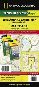
Yellowstone/grand Teton National Parks, Map Pack Bundle
Seeking the best combination of detailed maps and value for your Yellowstone/Grand Teton National Parks trip, then get our bundle pack. It includes both our Yellowstone National Park and Grand Teton National Park Trails Illustrated maps, providing...

Glacier/waterton Lakes National Parks
The Waterton Lakes NP section of the map includes Waterton Park, Upper and Middle Waterton Lakes, The Border Ranges, Akamina Kishinena Provincial Park, Blood Timber Reserve, and more. The Glacier National Park part covers the entire national park ...

Road Atlas: Scenic Drives Edition (united States, Canada, Mexico)
National Geographic's Road Atlas: Scenic Drives Edition, is the ideal companion for the next time you hit the road for an unforgettable road trip. Includes up-to-date road maps for all 50 U.S. States, plus Canada, Mexico, and Puerto Rico....

Road Atlas - Adventure Edition
National Geographic's Adventure Road Atlas is a rugged, 168-page road atlas that provides detailed maps of all 50 states, as well as Canada and Mexico. It features a tough, clear plastic cover and spiral binding to prevent wear and tear. The atlas...

Orlando
The newly redesigned National Geographic DestinationMaps series strikes the perfect balance between map and guidebook, and they are the ideal resource for touring culturally and geographically unique areas. All maps are double-sided with beautiful...

Las Vegas
The newly redesigned National Geographic DestinationMaps series strikes the perfect balance between map and guidebook, and they are the ideal resource for touring culturally and geographically unique areas. All maps are double-sided with beautiful...

Los Angeles
CityDestinationMaps blend urban guidebook information with easy to read street maps, complete with 3D buildings. The maps are printed on waterproof, tear-resistant material that's lightweight yet very durable. Double-sided with beautiful photos an...
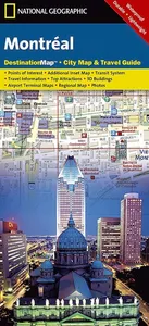
Montreal
The newly redesigned National Geographic DestinationMaps series strikes the perfect balance between map and guidebook, and they are the ideal resource for touring culturally and geographically unique areas. All maps are double-sided with beautiful...

Destination Toronto
Canada's capital city is covered with unparalleled detail in a unique package that combines a easy to read street map and travel guide. A regional map and an inset map of the city center, along with information about the city and its points of int...

North Carolina
National Geographic's North Carolina Guide Map is designed to meet the needs of travellers with detailed and accurate cartography and loads of helpful information about the state's many attractions. Hundreds of points of interest are shown, along ...
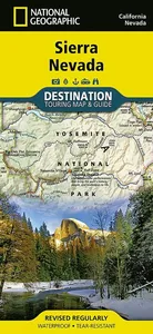
Sierra Nevada
National Geographic's Sierra Nevada Destination Map strikes the perfect balance between map and guidebook and is an ideal resource for touring this culturally and geographically unique region. Key features include: Double-sided map containing deta...

John Muir Trail (topographic Map Guide)
National Geographic's Map Guide of the John Muir Trail is an indispensable tool for navigating one of the most famous trails in the United States. The maps start at the northern terminus in Yosemite Valley and progress along the ridge of the Sierr...

Japan
National Geographic's Japan Adventure Map is designed to meet the unique needs of adventure travelers with its durability and accurate information. This folded map provides global travelers with the perfect combination of detail and perspective, highlighting hundreds of points of interest and the diverse and unique destinations within the country. The map includes the locations of cities and towns with a user-friendly index, plus a clearly marked road network complete with distances and designations for major highways, main roads, and tracks and trails for those seeking to explore more remote regions. Every Adventure Map is printed on durable synthetic paper, making them waterproof, tear-resistant and tough - capable of withstanding the rigors of international travel. Each is two-sided and can be folded to a packable size of 235 x 108 mm; unfolded size is 965 x 660 mm.

Tour du Mont Blanc Map Guide
• Waterproof • Tear-Resistant • Topographic Map Located in the northwetern Alps, between the Aosta Valley and Haute-Savoie, Mont Blanc is the highest mountain in Europe at 4,808 meters (15,774 feet). The central part of the Mont Blanc Massif, always snow-covered, consists of a mountain range that crosses Italy, France, and Switzerland. The Tour du Mont-Blanc (TMB) runs counterclockwise with start and finish in Les Houches, France. It covers approximately 170 km with clear signage, a 10,000-meter elevation gain (positive and negative), and takes 10 to 12 days to walk passing through France, Switzerland, and Italy. Travelers will have a chance to admire the spectacular landscapes: vast glacier areas, meadows rich in diverse flora, fascinating lunar-like rock landscapes, alpine pastures, charming villages, and refuges offering a comfortable place to rest The Tour du Mont-Blanc Topographic Map Guide booklet makes a perfect traveling companion when traversing this famous routes. A detailed

Middle East, Tubed
National Geographic Wall Maps offer a special glimpse into current and historical events, and they inform about the world and environment. Offered in a variety of styles and formats, these maps are excellent reference tools and a perfect addition to any home, business or school. There are a variety of map options to choose from, including the world, continents, countries and regions, the United States, history, nature and space.

Iceland
AdventureMaps provide global travellers with the perfect combination of detail and perspective. Iceland's western half is shown on the front side of the map including the cities of Reykjavik, Kpavogur, Mossfellsbaer, and Siglufj rdur. The reverse side covers the eastern portion of the country showing the cities of Akureyri, Egilsstadir, Eskifj rdur, Neskaupstadur, Hsavik, and H fn. Popular locations to ski, golf, camp, fish, and swim are marked, as are World Heritage sites, museums, churches, and other points of interest.

Western Balkans
Waterproof, Tear-Resistant Travel Map. The Western Balkans region, an adventure playground and rising star of Europe, is loaded with Old World traditions, slow food culture, ancient towns, and rarely visited villages. The area stretches from the Adriatic Sea in the west, up and over mountain ranges, raging rivers, tectonic lakes, steep gorges, and thousands of miles of paths, trails, and routes. Discover eight countries - all with their special brand of Balkan magic: Slovenia, Croatia, Bosnia and Herzegovina, Montenegro, Albania, Serbia, Kosovo, and Macedonia. National Geographic's Western Balkans Adventure Map will meet the needs of travelers with its detailed and accurate information. The map includes the locations of UNESCO World Heritage sites and exotic places to discover, including Slovenia's Triglav National Park, the walled city of Dubrovnik in Croatia, and the World Heritage Lake Ohrid in Macedonia. The map comes with a user-friendly index and clearly marked road network comp

Blue Ridge Parkway, USA
Waterproof, tear-resistant travel map. The Blue Ridge Parkway is a winding route that traverses some of America's most picturesque scenery. The Parkway is America's most visited National Park unit and when combined with Skyline Drive through Shena...

England And Wales Classic, Laminated
This classic-style map of England and Wales shows political boundaries, major highways and roads, cities and towns, airports and other geographic details. Thousands of place-names and exact borders are carefully researched by National Geographic s map researchers and editors ensuring the utmost accuracy. Scale: 1:868,000. Laminated. 91.4 x 76.2 cm.

World Classic, Poster Size, Laminated
The National Geographic Classic World Map is the perfect addition to any home, business or school. This smaller poster-size map (91 x 61 cm) features the entire world, laid out in bright, easy-to-read colours and fonts, as well as rich detail, thousands of place names and borders drawn with the utmost accuracy. It is ideal for anybody who wants to learn more about geography and political borders, world travellers who want to mark off where they have been and those who simply appreciate the joys of imagining faraway places. Laminated for protection against wear and tear.

Northern Spain
AdventureMaps provide global travellers with the perfect combination of detail and perspective, highlighting hundreds of points of interest and the diverse and unique destinations within the country. Each map is printed on durable synthetic paper, making them waterproof and tear-resistant. They also include the locations of cities and towns with a user-friendly index, plus a clearly marked road network complete with distances and designations for major highways, main roads and tracks and trails for those seeking to explore more remote regions.

Antarctica Satellite, Laminated
National Geographic Wall Maps offer a special glimpse into current and historical events, and they inform about the world and environment. Offered in a variety of styles and formats, these maps are excellent reference tools and a perfect addition ...

Colombia
AdventureMaps provide global travellers with the perfect combination of detail and perspective, highlighting hundreds of points of interest and the diverse and unique destinations within the country. Each map is printed on durable synthetic paper, making them waterproof and tear-resistant. They also include the locations of cities and towns with a user-friendly index, plus a clearly marked road network complete with distances and designations for major highways, main roads and tracks and trails for those seeking to explore more remote regions.

Costa Rica
AdventureMaps provide global travellers with the perfect combination of detail and perspective, highlighting hundreds of points of interest and the diverse and unique destinations within the country. Each map is printed on durable synthetic paper, making them waterproof and tear-resistant. This Costa Rica map contains detailed topographic information, plus useful traveling tips, regional information, and an inset map of the capital city of San Jos. Also includes the locations of popular diving, fishing, and surfing spots, plus comprehensive protected area boundaries and roads.
![Haute Route Map [chamonix To Zermatt]](https://find.to/img/978/156/69/9781566958103.webp)
Haute Route Map [chamonix To Zermatt]
Waterproof, Tear-Resistant, Topographic Map.The Haute Route-aka the High Route or Mountaineers' Route-traverses the French and Swiss Alps. It was conceived as a summer mountaineering route in the mid-nineteenth century by members of the English Alpine Club. Though originally called 'The High-Level Route' by members of the Alpine Club, in 1911, a group first successfully established a winter route from Bourg St. Pierre to Zermatt on skis and afterwards the name of the route was translated into French. As a result of their success, the French term stuck, and the journey gained a reputation amid skiers and ski mountaineers as a classic must-do winter/spring tour. There is also a non-technical Walker's Haute Route that has gained in popularity and become a classic in and of itself. This Topographic Map Guide outlines two different variations of the Haute Route from Chamonix, France to Zermatt, Switzerland: one for hikers and one for skiers. The northernmost route or, Walker's Route, depic

New Zealand
AdventureMaps provide global travellers with the perfect combination of detail and perspective. The north side of the map details New Zealand's north island including Auckland, Wellington, Hauraki Gulf Maritime Park, Egmont National Park, Te Urewera National Park slands. The south side covers the south island and details places including Marlborough Sounds Maritime Park, Christ Church, Fiordland National Park, and Stewart Island. Six inset maps provide locations for islands off the coast of New Zealand, providing coverage for the entire country.

Sicily
AdventureMaps provide global travellers with the perfect combination of detail and perspective, highlighting hundreds of points of interest and the diverse and unique destinations within the country. Each map is printed on durable synthetic paper, making them waterproof and tear-resistant. They also include the locations of cities and towns with a user-friendly index, plus a clearly marked road network complete with distances and designations for major highways, main roads and tracks and trails for those seeking to explore more remote regions.

Baja California, Mexico, Map Pack Bundle
AdventureMaps provide global travellers with the perfect combination of detail and perspective, highlighting hundreds of points of interest and the diverse and unique destinations within the country. Each map is printed on durable synthetic paper,...
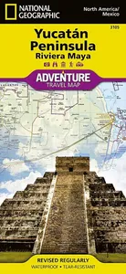
Northern Yucatn/maya Sites, Mexico
AdventureMaps provide global travellers with the perfect combination of detail and perspective. The Northern Yucatn Peninsula and Maya Sites map provides unmatched detail and information for the highly popular Yucatn Peninsula and its important Ma...

Pyrenees And Andorra
AdventureMaps provide global travellers with the perfect combination of detail and perspective, highlighting hundreds of points of interest and the diverse and unique destinations within the country. Each map is printed on durable synthetic paper,...

Bolivia
AdventureMaps provide global travellers with the perfect combination of detail and perspective, highlighting hundreds of points of interest and the diverse and unique destinations within the country. Each map is printed on durable synthetic paper,...

Philippines
AdventureMaps provide global travellers with the perfect combination of detail and perspective, highlighting hundreds of points of interest and the diverse and unique destinations within the country. Each map is printed on durable synthetic paper,...

Sardinia
AdventureMaps provide global travellers with the perfect combination of detail and perspective, highlighting hundreds of points of interest and the diverse and unique destinations within the country. Each map is printed on durable synthetic paper,...